
Second SEALT-Discovery walk
Traversing the 2014 wetlands conservation parcel On July 16th, about 25 bushwackers assembled in the parking area at end of…
2022 | Richard Carstensen | 11 minute slideshowDiscoverySoutheast.org


Bold red line surrounds the greater Áak’w Táak watershed. Thinner lines delineate what we began to call “subsheds” during 2014 wetland surveys for the City.
For this gigantic, 99.3-squaremile watershed, I’ve settled on rather unconventional subdivisions. More social than hydrologic, my 4 unit names reflect the way we use em, rather than according to patterns of waterflow. Moving upvalley, the units are: 1) Flats, 2) Homes, 3) Rec, 4) Ice.
Only a few mountaineers have spent more than an hour or two trekking over that austere upper unit. But it’s important to have at least a visual image of the sea of ice that feeds Áak’w Táak Sít’i, glacier of little-lake valley. So here’s a 90-second digital flyover.
In 2025, for our annual end-of-school-year teacher seminar, we walked pretty much the entirety of Woosh eel’óox̱’u héen, river that’s murky together (M-word R.). This covered all but the 4th, glacial subunit of the watershed. Proceeding downriver (units, 3, 2 and 1, respectively) over 3 successive days, we chose themes for each segment: where we play, ● where we live ● what feeds us. My 2025 class journal explores those themes of recreation, residence and sustenance. It also, of course, addresses the liabilities of playing, living and foraging below an ice-margin impoundment.
Discovery is taking on larger roles in The Valley. Due in part to our presence at the glacier visitor center, we’ve been well positioned to help fill the void of federal losses. We’re collaborating with Tlingit-Haida cultural ambassadors to host visitors and enhance their experience. We will also be assisting the Southeast Alaska Watershed Coalition (SAWC) as they, in turn, help the City grapple with multitudinal consequences of annual outburst flooding.
No consultant’s crystal ball can tell us how best to respond to this unique and unprecedented situation. Even the floods of 2023 and 2024 were quite different. It will take all of us—specialists & generalists, doers & thinkers—to iteratively figure out, and survive, this glacio-fluvial roller coaster ride.

SW over lower the flats to Áak’w Tá, little lake bay (Auke Bay). On the right, willow-alder wetlands advance onto raised tideland. In left mid-distance, Widgeon Ponds sit on compacted silt. ● On May 25th, 2018, to celebrate school’s end, Discovery Naturalists Steve Merli, John Hudson and I accompanied 50 teachers and staff from Dzantik’i Héeni Middle School across tidal flats at the bottom of Taashuyee, river, tide, or mudflats (M-word wetlants). We started at the end of Peninsula Road and got picked up at Industrial Boulevard. The walk traversed lovely salt marsh and uplift meadows at peak of spring migration. Here’s a slideshow summary.

East over mouth of Steep Creek to the Visitor Center, April, 2002. Not surprisingly, we have no Lingít place names for these features that were ice covered until the mid-1900s.

Three geopdfs for Áak’w Táak: 1) the ‘greater’ watershed, from IfSAR; 2) & 3) more detail for upper and lower inhabited portions.
For navigation, I’ve prepared many geopdfs that you can load to the app Avenza, described in TOOLS>Field navigation Basemaps are mostly high-res bare earth from 2013 CBJ LiDAR, and coarser 5-m pixel hillshade from IfSAR.
PS 2025: The GIS community continues to receive updated air photography and LiDAR, so keep checking for new geopdfs for your favorite hiking and bushwacking destinations, linked from this category page (In this section, below), or under Media types>Maps.
Traversing the 2014 wetlands conservation parcel On July 16th, about 25 bushwackers assembled in the parking area at end of…
2022 | Richard Carstensen | 11 minute slideshow
Environmental analysis of lower Jordan Creek From March through July, 1987, I assisted Dan Bishop and Bob Armstrong with an…
1987 | Bishop, Armstrong & Carstensen | 40 pages
Fifty friends on backloop moraines On a sunny July 17th, 2021, Discovery Southeast and the Southeast Alaska Land Trust hosted…
2021 | Richard Carstensen | 8 minute slideshow
Touring lands on Back Loop Road Discovery Southeast and the Southeast Alaska Land Trust (SEALT) have similar missions. Discovery works…

Year-3: Estuaries & steep places Two kinds of landforms & habitats have consumed my attention this winter and spring—estuaries and…
2021 | Richard Carstensen | 60 page journal & course manual
Frontyard wetlands in StoryMaps Every May is American Wetlands Month, and this year, it’s especially interesting for residents of Áak’w…

Our frontyard wetlands in StoryMaps For several years I’ve been wanting to dive into ArcGIS StoryMaps, cartography for one and…
2021 | USFWS | ArcGIS StoryMap
Zonotrichia passage through the Highlands May 3rd, 2022. Golden-&-white-crowned sparrows are flooding through our neighborhood’s garden rows and brush borders.…
2021&22 | Richard Carstensen | short captioned videos
Effects of age and succession type on forest overstory and understory In 1991 I assisted highschool students Joey Bosworth and…
1991 | Joey Bosworth & Erika O'Sullivan | 1 page poster
Goat-watch at Áak’w Kwáan Sít’i (Áak’w people’s glacier) 20201203: Every other Friday, Discovery staff get together for a ‘distanced’ outing.…
2020 | Richard Carstensen | 2 page journal
Materials from the Eisenhower Math and Science series In February, 1991, with Gustavus master-naturalist Greg Streveler, Discovery director Cinda Stanek…
1991 | Carstensen, Streveler, Stanek & Merli | workshop materials
Materials from the Eisenhower Math and Science series In October, 1990, with Discovery director Cinda Stanek and naturalist Steve Merli,…
1990 | Carstensen, Stanek, Merli | workshop materials
Rebound, succession, fish&wildlife, and aviation on our frontyard wetlands In 2011, Jeff Sauer at Juneau Audubon asked for a presentation…
2011 | Richard Carstensen | 36-minute slideshow
Northbound swans, Áak’w Táak, inland from little lake (M-word Valley) April 4th, 2020. For the past week or more, birders…
2020 | Richard Carstensen | 3-minute video
Beginning in late 2001, on contract with Airport EIS consultants SWCA, Bob Armstrong and I spent a full year surveying…
2004 | Richard Carstensen & Bob Armstrong | 14 pages
High-resolution GeoPDF pair for field navigation at Kaxdigoowu Héen, going back clear water (Montana Creek). In apps such as Avenza, on…
2018 | Richard Carstensen | 2 geoPDFs
Medium-resolution GeoPDF pair for field navigation in Aak’w Táak, inland from little lake (Mendenhall Valley) and contributing valleys or ‘tribsheds’.…
2018 | Richard Carstensen | 2 geoPDFs
High-resolution GeoPDF pair for field navigation in upper Áak’w Táak, inland from little lake (Mendenhall Valley). Includes on-foot destinations from…
2018 | Richard Carstensen | 2 geoPDFs
geopdf_valleyloweraerial2019 High-resolution GeoPDF pair for field navigation in lower Áak’w Táak, inland from little lake (Mendenhall Valley). Includes on-foot destinations…
2018 | Richard Carstensen | 2 geoPDFs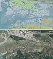
High-resolution GeoPDF pair for field navigation on the Airport Dike Trail and adjacent tidal wetlands. Also shows coastline on the…
2018 | Richard Carstensen | 2 geoPDFs