Seaforms & the Great Wave of 2025
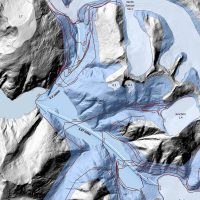
Mountainside detachment in North S’awdáan Fiord (Tracy Arm) On August 10th, 2025, an enormous section of mountain fell into the…
2026 | Richard Carstensen | 46 page pdf 24mbDiscoverySoutheast.org

Mapping is one of the core skills of the naturalist. Today, that mostly means GIS (geographic information systems), here divided into ArcMap, LiDAR and IfSAR. Explore those sub-categories or view the entire JuneauNature hierarchy at this site map.
A standard step for me in scoping any new project area in Lingit Aani is to assemble all historical photography. Earliest aerial cartographic missions were by the US Navy, in 1929 and 1948. An introduction to these resources is in Historic photo missions.
 Toggling through the resulting time series, preferably as same-aligned ‘pageflippers’ on successive pages of a pdf, helps to understand how landforms and plant communities change. Next, I layer-on all the standard points, lines and polygons: Lingít place names, channel-types, geology, for example. Preparing a talk for the Wildlife Society on Focus and breadth, it occurred to me that while scientists ‘focus,’ a naturalist aspires to be broad. And one of the best ways to spread out our Strevelerian peripheral vision is to dabble in ‘foreign disciplines’—through the constellations of map layers prepared by experts.
If I could give one piece of advice to a high school student contemplating a career in forestry, fisheries, wildlife biology, geology, or any social science with a geographic component, it would be to take a course in GIS, the way we make ‘intelligent’ maps. Demand for facility in GIS will only increase through coming decades.
In Map-making with children, a book that’s been important to Discovery naturalists since our founding, David Sobel pointed out that that graphicacy—logical partner to the other ‘acy’s of liter-, numer- and articulacy—has been better understood and nurtured in Britain than in the Americas. When you can’t explain something verbally, so, draw a diagram or map in the mud, or pull out your phone to show the picture you took, you’re practicing graphicacy.
Allow me just one example of “ill-graphicacy,” as annoying to the cartographically fluent as illiteracy is to the well-read. This malapropism displays reliance on secondary sources; ie, everyone else says it, so it must be correct.
Satellite images?! Hmmmm. . . .Even knowledgeable bio–&-geologists routinely refer to online app-imagery as “satellite” photos. Whether from Google Earth, BING, or ArcGIS Online, they are rarely from satellites. An obvious clue is tree-lean. On true satellite imagery, or even very high plane-base photos such as the Navy 1948s or NASA 1979s, tree crowns are centered and ‘straight-up appearing. In contrast on an orthomosaic, stitched from photos taken only a few thousand feet up, trees around the edges of each image will appear to lean
Mountainside detachment in North S’awdáan Fiord (Tracy Arm) On August 10th, 2025, an enormous section of mountain fell into the…
2026 | Richard Carstensen | 46 page pdf 24mb
From theodolite to LiDAR Teaching geol-393—Reading the landscape of northern Lingít Aaní—with my friend Cathy Connor in fall 2022, I…
2022 | Richard Carstensen | 14 pages
Flying Taashuyee-Chookan.aani For their 2024 February Watershed Workshop, SAWC (Southeast Alaska Watershed Coalition) asked me for some thoughts on drones…
2024 | Richard Carstensen | 16 minute narrated slideshow
Vegetation-&-rebound study for Southeast Alaska Land Trust (SEALT) In 2003, Discovery Southeast mapped tidal and supratidal habitats on the Refuge…
2004, update 2023 | Richard Carstensen | 39 pages
Releases in Nettleslide (Behrends path) & Last Chance Goatwatching in winter leads inevitably to fascination with avalanches. Yesterday, Feb 12,…
2022 | Richard Carstensen |
Focus group tour On Thursday, August 26th, about 30 masked aficionados of dynamic Fish Creek delta assembled on invitation from…
2021 | Richard Carstensen, Bob Armstrong | RC-59 pages: BA vid-links
Frontyard wetlands in StoryMaps Every May is American Wetlands Month, and this year, it’s especially interesting for residents of Áak’w…

Our frontyard wetlands in StoryMaps For several years I’ve been wanting to dive into ArcGIS StoryMaps, cartography for one and…
2021 | USFWS | ArcGIS StoryMap
Materials from the Eisenhower Math and Science series In October, 1990, with Cathy Pohl and Gretchen Bishop, I gave a…
1991 | Carstensen, Pohl, Bishop | workshop materials
Materials from the Eisenhower Math and Science series In February, 1991, with Gustavus master-naturalist Greg Streveler, Discovery director Cinda Stanek…
1991 | Carstensen, Streveler, Stanek & Merli | workshop materials
Materials from the Eisenhower Math and Science series In October, 1990, with Discovery director Cinda Stanek and naturalist Steve Merli,…
1990 | Carstensen, Stanek, Merli | workshop materials
Materials from the Eisenhower Math and Science series Discovery Southeast was born at Harborview Elementary, under the tuteladge of master-teachers…
1991 | Carstensen, Streveler & Pohl | workshop materials
Hydrology in the point cloud. Maybe it’s all those years stippling scenes and species portraits, point by point with double-ought…
2020 | Richard Carstensen | 2-minute slideshow
A fireside presentation My talk at the Visitor Center in February, 2020 explored the past 20,000 years of glaciation and…
2020 | Richard Carstensen | 27 minutes
In 2008, Bob Christensen and I were 3 years into the Ground-truthing Project. During those 3 years, the Forest Service…
2008 | Carstensen & Christensen | 30 pages
The Ground-truthing Project, sponsored by Sitka Conservation Society, ran from 2005 to 2010. Kenyon Fields at SCS administered the program,…
2005 | Carstensen & Christensen | 63 pages
Hover over each numbered province; a click takes you to that sub-category
Richard Carstensen | 1 page
New ideas about forest structure Seeing the forest through a deer’s eyes. Thoughts on forest structure and habitat values, resulting…
Winter 2003 | Richard Carstensen | 12 pages
Bedrock geology for Áak’w & T’aakú Aaní. Units based upon a shapefile by USGS, but color coded by 6 broad…
2015: update 2022 | Richard Carstensen |
This document assembles aerial imagery and other GIS-based maps of Montana Creek for use by teachers in class and field.…
2013 | Richard Carstensen | 22 pages