
Supplement to the CBJ wetlands surveys, 2016
In summer 2014, Koren Bosworth, Cathy Pohl, Andrew Allison and I surveyed wetlands throughout the CBJ. Although we were not…
2016 | Richard Carstensen | 31 page excerpt (of 512p)DiscoverySoutheast.org


Bold red line surrounds the greater Áak’w Táak watershed. Thinner lines delineate what we began to call “subsheds” during 2014 wetland surveys for the City.
For this gigantic, 99.3-squaremile watershed, I’ve settled on rather unconventional subdivisions. More social than hydrologic, my 4 unit names reflect the way we use em, rather than according to patterns of waterflow. Moving upvalley, the units are: 1) Flats, 2) Homes, 3) Rec, 4) Ice.
Only a few mountaineers have spent more than an hour or two trekking over that austere upper unit. But it’s important to have at least a visual image of the sea of ice that feeds Áak’w Táak Sít’i, glacier of little-lake valley. So here’s a 90-second digital flyover.
In 2025, for our annual end-of-school-year teacher seminar, we walked pretty much the entirety of Woosh eel’óox̱’u héen, river that’s murky together (M-word R.). This covered all but the 4th, glacial subunit of the watershed. Proceeding downriver (units, 3, 2 and 1, respectively) over 3 successive days, we chose themes for each segment: where we play, ● where we live ● what feeds us. My 2025 class journal explores those themes of recreation, residence and sustenance. It also, of course, addresses the liabilities of playing, living and foraging below an ice-margin impoundment.
Discovery is taking on larger roles in The Valley. Due in part to our presence at the glacier visitor center, we’ve been well positioned to help fill the void of federal losses. We’re collaborating with Tlingit-Haida cultural ambassadors to host visitors and enhance their experience. We will also be assisting the Southeast Alaska Watershed Coalition (SAWC) as they, in turn, help the City grapple with multitudinal consequences of annual outburst flooding.
No consultant’s crystal ball can tell us how best to respond to this unique and unprecedented situation. Even the floods of 2023 and 2024 were quite different. It will take all of us—specialists & generalists, doers & thinkers—to iteratively figure out, and survive, this glacio-fluvial roller coaster ride.

SW over lower the flats to Áak’w Tá, little lake bay (Auke Bay). On the right, willow-alder wetlands advance onto raised tideland. In left mid-distance, Widgeon Ponds sit on compacted silt. ● On May 25th, 2018, to celebrate school’s end, Discovery Naturalists Steve Merli, John Hudson and I accompanied 50 teachers and staff from Dzantik’i Héeni Middle School across tidal flats at the bottom of Taashuyee, river, tide, or mudflats (M-word wetlants). We started at the end of Peninsula Road and got picked up at Industrial Boulevard. The walk traversed lovely salt marsh and uplift meadows at peak of spring migration. Here’s a slideshow summary.

East over mouth of Steep Creek to the Visitor Center, April, 2002. Not surprisingly, we have no Lingít place names for these features that were ice covered until the mid-1900s.

Three geopdfs for Áak’w Táak: 1) the ‘greater’ watershed, from IfSAR; 2) & 3) more detail for upper and lower inhabited portions.
For navigation, I’ve prepared many geopdfs that you can load to the app Avenza, described in TOOLS>Field navigation Basemaps are mostly high-res bare earth from 2013 CBJ LiDAR, and coarser 5-m pixel hillshade from IfSAR.
PS 2025: The GIS community continues to receive updated air photography and LiDAR, so keep checking for new geopdfs for your favorite hiking and bushwacking destinations, linked from this category page (In this section, below), or under Media types>Maps.
In summer 2014, Koren Bosworth, Cathy Pohl, Andrew Allison and I surveyed wetlands throughout the CBJ. Although we were not…
2016 | Richard Carstensen | 31 page excerpt (of 512p)
Supplement to the 2016 Juneau Wetlands Management Plan In summer 2014, Koren Bosworth, Cathy Pohl, Andrew Allison and I surveyed…
2018 | Richard Carstensen | 8 separate pdfs, 2 to 5 MB
During the Armstrong-Willson-Carstensen Hotspots study, 2002-03, Mary Willson teamed with Aaron Baldwin to sample intertidal invertebrates throughout the Mendenhall Refuge.…
2004 | Mary Willson & Aaron Baldwin | 42 pages
Yellowlegs, peeps, and northbound songbirds on the Refuge dike trail.
2017 | Richard Carstensen | 90 seconds
Discovery Southeast celebrates 4 decades of research and education at Áak’w Táak, inland from little lake (Mendenhall Valley) glacierdiscovery from…
2017 | Richard Carstensen | 27 minutes
Aerial views of post-glacial succession. Combines UAV perspectives with high-res orthophotography plus forest profile views in the LiDAR point cloud.…
2017 | Richard Carstensen | 20 minutes
Filmed all these clips in less than 2 hours at Mendenhall Visitor Center today. Never would have guessed what a…
2017 | Richard Carstensen | 3 minutes
Part of a 2012 slide show for Juneau-Douglas City Museum on Alaskan landscape painter Sydney Laurence. I co-presented with Mike…
2012 | Richard Carstensen | 17 minutes
In 2009, with support from the Southeast Alaska Land Trust, Bob, Mary, Marge and I distilled much of the information…
2009 | Armstrong, Carstensen, Willson and Osborn | 82 pages
Discovery naturalists Steve Merli, John Hudson and Richard Carstensen walked from end Mendenhall Peninsula Road to Industrial Boulevard with staff…
2018 | Richard Carstensen | 4:21 minutes
High-resolution GeoPDF pair for field navigation around Chookan Aaní, grassy land (Mendenhall Peninsula) and the western Refuge, where Pederson Creek…
2018 | Richard Carstensen | 2 geoPDFs
In 2013 I participated in a 3 day teacher’s conference called STREAM: a Pedagogy of Place. During this “place-based” conference…
2013 | Richard Carstensen | 7 pages
As Kathy Hocker and I built up Discovery’s library of historical photographs, during our Repeat Photography Project in 2004-2005, we…
2012 | Richard Carstensen | 10 min; 25 min
A Discovery Guide for the independent traveler who wishes to visit the Mendenhall Glacier by bus and foot. Inspired by…
2009 | Richard Carstensen | 2 pages, 3 MB
Another great example of Bob Armstrong’s many collaborations with experts, in this case Chiska Derr. Beautifully illustrated guide to lichens…
2010 | Bob Armstrong & Chiska Derr | 50 pages
Documenting change through repeat photography in Southeast Alaska Carefully framed retakes of historical photographs documenting vegetation and landform change in…
2005: 2nd ed, 2013 | Richard Carstensen, Kathy Hocker | 39 pages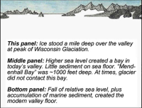
At Juneau, marine sediments dating to 13,000 BP have been found at 750 feet above sea level. Considering world sea…
2013 | Richard Carstensen |
Collection of maps and images spanning the past century shows glacial retreat the forest succession,.Áak’w Kwáan Sít’i, Áak’w peoples’ glacier…
2013 | Richard Carstensen | 10 pages
Introduction to a keystone species in recently deglaciated upper Áak’w Táak, inland from little lake (Mendenhall Valley). Can’t picture beavers…
2009 | Bob Armstrong|Mary Wilson | 62 pages
Summary of a 14 month bird survey on Mendenhall Wetlands State Game Refuge, undertaken on request from US Fish &…
2004 | Robert Armstrong, Richard Carstensen, Mary Willson | 77 pages