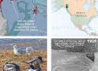
High-resolution GeoPDF pair for field navigation around Chookan Aaní, grassy land (Mendenhall Peninsula) and the western Refuge, where Pederson Creek meets Wushil’ux‘u Héen, milky water (Mendenhall River). In apps such as Avenza, on your phone or tablet, you can see your GPS/cell-triangulation position on this image, and lay a track.
First choice below is a LiDAR-derived bare-earth hillshade with modeled streams and 10-foot contours. Other layers, exported from ArcMap, are named roads and our wetland units from the CBJ wetland survey project. Thick blue lines are “subsheds,” also mapped during that project. The bold blue line at Extreme High Water extends far up streams and sloughs. Upper limits of the green tint at 32 feet show maximum tidal incursion at peak Little Ice Age—well upvalley from this map.
The second choice is a 2013 orthophoto with overlain streams. More information on geoPDFs and use of Avenza is at Media types>Maps&geoPDFs., and at Tools>Field navigation. On low tides it’s possible to walk farther toward the rivermouth than indicated on these maps. The aerial view was taken at about a 10-foot tide—boundary between dark blue and grey-blue on the hillshade. But if you go farther southwest, BEWARE and check tide tables. It’s very flat out there and the tide can come in rapidly.
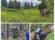
A 4-minute narrated video of our teachers’ walk through the Wigeon Ponds area is here.
Download hillshade geoPDF here (5MB)![]()

Download aerial geoPDF here (14MB)![]()