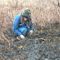
Grassfire on SEALT wetlands, May, 2023
Nine acres torched in Yellowthroat Carr A carr is a scrub wetland with woody-stemmed dominants—a term we hear more often…
2023 | Richard Carstensen | 10 page pdfDiscoverySoutheast.org


Bold red line surrounds the greater Áak’w Táak watershed. Thinner lines delineate what we began to call “subsheds” during 2014 wetland surveys for the City.
For this gigantic, 99.3-squaremile watershed, I’ve settled on rather unconventional subdivisions. More social than hydrologic, my 4 unit names reflect the way we use em, rather than according to patterns of waterflow. Moving upvalley, the units are: 1) Flats, 2) Homes, 3) Rec, 4) Ice.
Only a few mountaineers have spent more than an hour or two trekking over that austere upper unit. But it’s important to have at least a visual image of the sea of ice that feeds Áak’w Táak Sít’i, glacier of little-lake valley. So here’s a 90-second digital flyover.
In 2025, for our annual end-of-school-year teacher seminar, we walked pretty much the entirety of Woosh eel’óox̱’u héen, river that’s murky together (M-word R.). This covered all but the 4th, glacial subunit of the watershed. Proceeding downriver (units, 3, 2 and 1, respectively) over 3 successive days, we chose themes for each segment: where we play, ● where we live ● what feeds us. My 2025 class journal explores those themes of recreation, residence and sustenance. It also, of course, addresses the liabilities of playing, living and foraging below an ice-margin impoundment.
Discovery is taking on larger roles in The Valley. Due in part to our presence at the glacier visitor center, we’ve been well positioned to help fill the void of federal losses. We’re collaborating with Tlingit-Haida cultural ambassadors to host visitors and enhance their experience. We will also be assisting the Southeast Alaska Watershed Coalition (SAWC) as they, in turn, help the City grapple with multitudinal consequences of annual outburst flooding.
No consultant’s crystal ball can tell us how best to respond to this unique and unprecedented situation. Even the floods of 2023 and 2024 were quite different. It will take all of us—specialists & generalists, doers & thinkers—to iteratively figure out, and survive, this glacio-fluvial roller coaster ride.

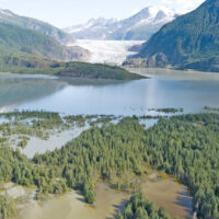
SW over lower the flats to Áak’w Tá, little lake bay (Auke Bay). On the right, willow-alder wetlands advance onto raised tideland. In left mid-distance, Widgeon Ponds sit on compacted silt. ● On May 25th, 2018, to celebrate school’s end, Discovery Naturalists Steve Merli, John Hudson and I accompanied 50 teachers and staff from Dzantik’i Héeni Middle School across tidal flats at the bottom of Taashuyee, river, tide, or mudflats (M-word wetlants). We started at the end of Peninsula Road and got picked up at Industrial Boulevard. The walk traversed lovely salt marsh and uplift meadows at peak of spring migration. Here’s a slideshow summary.

East over mouth of Steep Creek to the Visitor Center, April, 2002. Not surprisingly, we have no Lingít place names for these features that were ice covered until the mid-1900s.

Three geopdfs for Áak’w Táak: 1) the ‘greater’ watershed, from IfSAR; 2) & 3) more detail for upper and lower inhabited portions.
For navigation, I’ve prepared many geopdfs that you can load to the app Avenza, described in TOOLS>Field navigation Basemaps are mostly high-res bare earth from 2013 CBJ LiDAR, and coarser 5-m pixel hillshade from IfSAR.
PS 2025: The GIS community continues to receive updated air photography and LiDAR, so keep checking for new geopdfs for your favorite hiking and bushwacking destinations, linked from this category page (In this section, below), or under Media types>Maps.
Nine acres torched in Yellowthroat Carr A carr is a scrub wetland with woody-stemmed dominants—a term we hear more often…
2023 | Richard Carstensen | 10 page pdf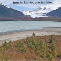
Drone tour in spring, 2017 I’m only just putting up this slideshow for the vast glacial foreland stretching southeastward from…
2017: posted 2026 | Richard Carstensen | 4-minute videotour
More white stuff My last post—on trumpeter swans—was only 3 days ago, and I try not to nature-nerd your inbox…
How did the flood behave away from our river corridor? During the August 13th outburst flood a TFR (temporary flight…
2025 | Sean Neilson & Richard Carstensen | 2-minute slideshow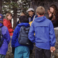
A guide to the natural and cultural history of our backyard glacial river. Another in the series of student written…
1997, update 2025 | ALDER House with Andy Romanoff | 18 pages
Early-morning birdsong & veg-structure surveys In spring and early summer of ’86, until birdsong tapered off, Koren Bosworth and I…
1986 | Richard Carstensen | 20 pages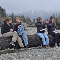
Top to bottom: Walking Woosh eelʼóox̱ʼu héen (Mendenhall River) Our 7th annual teacher seminar focuses on the landform at top…
2025 | Richard Carstensen | links to resources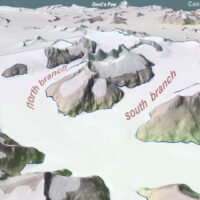
What we can’t see from Visitor Center I’m told by interpretive staff that visitors are often surprised to learn from…
2025 | Richard Carstensen | 90 second slideshow
Glacial topography on 2023 LiDAR terrain model We recently received a new LiDAR dataset commissioned by USGS, that just barely…
2025 | Richard Carstensen | 1 minute slideshow
History from the air Georeferencing old and recent vertical air photos in ArcMap makes it easy to export exactly scaled-&-aligned…
2021 | Richard Carstensen | 11 pages
History from the air Georeferencing old and recent vertical air photos in ArcMap makes it easy to export exactly scaled-&-aligned…
2021 | Richard Carstensen | 15 pages
History from the air Georeferencing old and recent vertical air photos in ArcMap makes it easy to export exactly scaled-&-aligned…
2021 | Richard Carstensen | 18 pages
When the lake freezes 20170205 Remarkable diversity of photo- and video-opportunities on this February walk to the terminus. Ice caves…
2017 | Richard Carstensen | 2 minute slideshow
Tracking & navigation workshop, upper Áak’w Táak (M-word Valley) Discovery Southeast has a strong relationship with the Forest Service’s Glacier…
2024 (& 2017) | Richard Carstensen | 4- & 2-minute slideshows, 17MB journal
Flying Taashuyee-Chookan.aani For their 2024 February Watershed Workshop, SAWC (Southeast Alaska Watershed Coalition) asked me for some thoughts on drones…
2024 | Richard Carstensen | 16 minute narrated slideshow
Mapping and observations in 1995 In June, 1995, I mapped lower ‘Duck Creek triangle,’ a sliver of fenced-off remnant tidelands…
1995, updated 2024 | Richard Carstensen | 16 pages
Checklist for our frontyard birds In 2002, as several of us embarked upon a year-long study of the birds of…
2018 | Richard Carstensen | 1 page
We live in kind-of a bowling alley . . . . . . so one might hope we’ve become more…
2023 | Richard Carstensen | 50-second video; pdf downloads
Vegetation-&-rebound study for Southeast Alaska Land Trust (SEALT) In 2003, Discovery Southeast mapped tidal and supratidal habitats on the Refuge…
2004, update 2023 | Richard Carstensen | 39 pages
Morning: In the morning we visited coastal sites at Aanchg̱altsóow, nexus town (Auke Rec) and K’aan Héenak’u, porpoise little bay…
2022 | Richard Carstensen | Landforms class archives