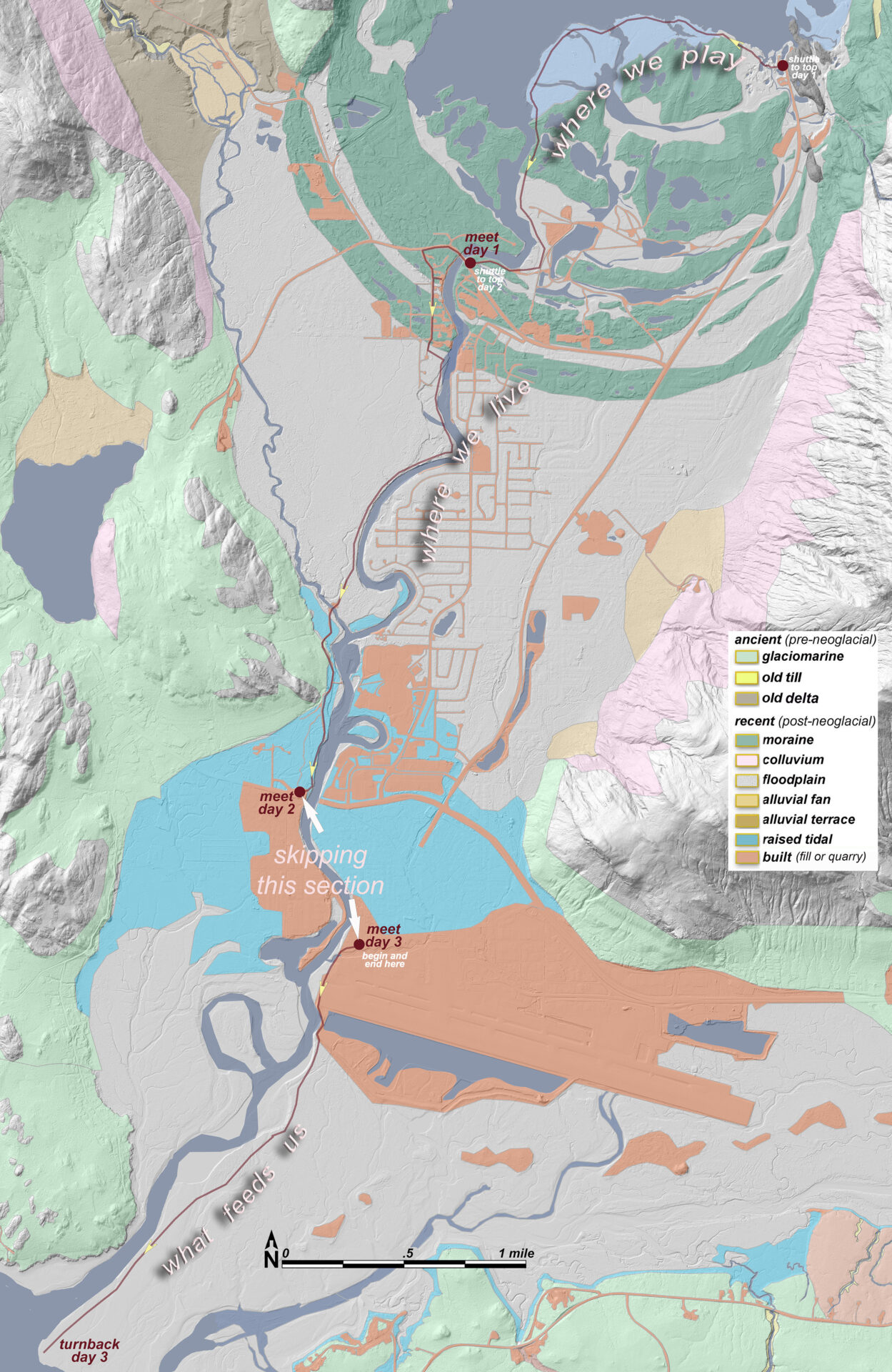
You could think of our 3 days thematically: 1) where we play; 2) where we live, and 3) what feeds us
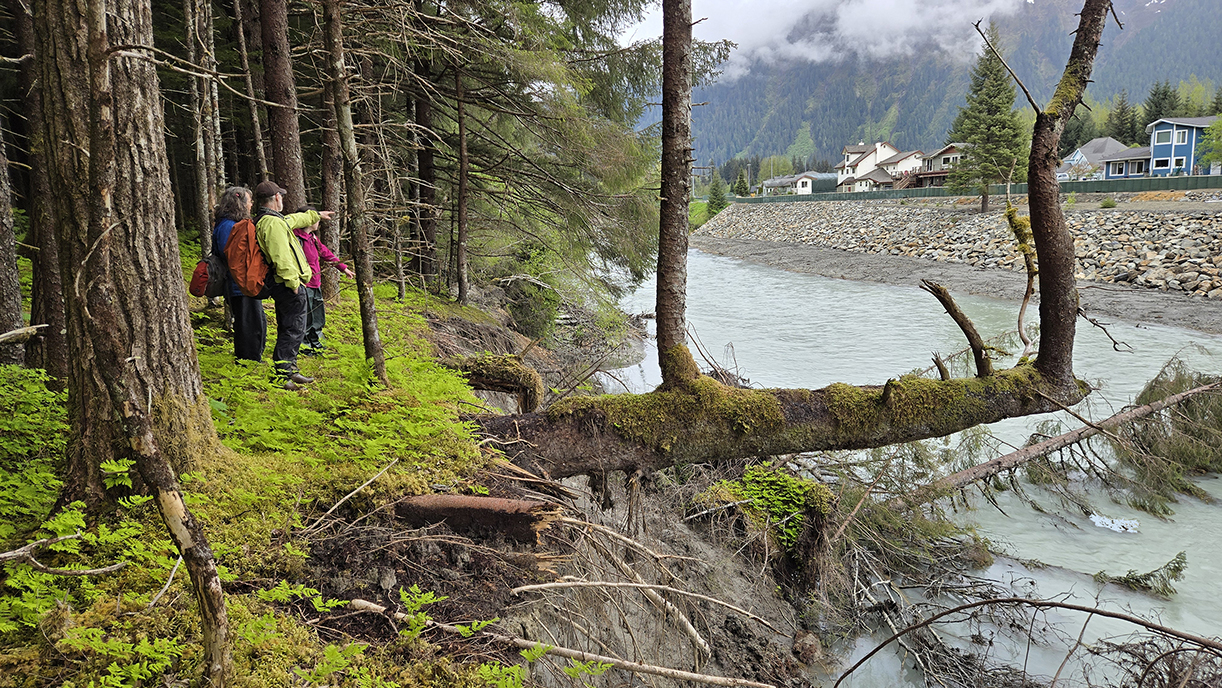
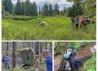
Scouting a key section, across from Riverview Condos. Can you figure out the story of this ‘tuning-fork’ tree?
Top to bottom: Walking Woosh eelʼóox̱ʼu héen (Mendenhall River)
Our 7th annual teacher seminar focuses on the landform at top of everyone’s mind since August, 2023, when we learned to pronounce jökulhlaup.
Field trip destinations:
Our general pattern will be to convene each morning at the ‘bottom’ of the walk, then shuttle with half our vehicles to the top.
● Friday, May 30, 9am-3pm—Rec Area Meet at Back Loop Bridge parking across from Mendenhall River School. Shuttle to start of walk at Glacier Visitor Center.
● Saturday, May 30, 9am-3pm—Center Valley Meet at Brotherhood Bridge Parking. Shuttle to Back Loop Bridge.
● Sunday, June 1, 9am-3pm—Tide flats. Meet at Airport Dike Trail Parking. We’ll walk the wetlands down to zero tide, but end back at our cars.
McLain has set up a group Google photos album. If we all load our 3-to-5 favorite photos from each day’s walk, we’ll have a lovely record of the river-study. With your permission I’ll include many of them in the journal.
Resources for exploring the river, and sharing it with your students:
Required text (for those enrolled for credit):
● Carstensen, 2025. Top to bottom: Walking Woosh eelʼóox̱ʼu héen (Mendenhall River) Scoping and journal for our class. This’ll be in pretty skeletal form during the class, but will go out to everyone afterward. Download 5MB draft here.![]() And keep checking back for updated drafts!
And keep checking back for updated drafts!
Strongly recommended:
● Juneau glacial flooding dashboard. UAS site for maps, forecasting, etc
● Heart of Juneau Portal for resources on Taashuyee/Chookan.aani (Mendenhall wetlands)
Links within JuneauNature:
First, some slideshows and downloads pertinent to individual segments of our river seminar:
Friday—rec area:
●.2024 Discovery off-trail. Journal pdf and slideshows.
●.2017 Raven’s eye. Aerial views of post-glacial succession. 20-minute slideshow
● 2017 Discovery’s education and research at The Glacier 27-minute slideshow
Saturday—central valley:
● 20241028_footbridge journal. ![]() Exploring flood features with Steve at beginning of his year with TM Middleschool.
Exploring flood features with Steve at beginning of his year with TM Middleschool.
● Dodging nature’s tantrums. This page on JuneauNature is dedicated to all manner of ‘serious stuff coming downhill.‘ Mudslides and snow avalanches are obvious ones, but glacial outburst floods, gentler in terms of slope, are still gravity-driven phenomena, that in fact have damaged way more homes than the steeper releases. Download the report called 20230805 Jökulhlaup on Wooch Eelʼóox̱ʼu héen. Mapping and photo-essay for friends along the river.
●.2022 Off trail in Áak’w Táak Second annual Discovery & Land-Trust members bushwack. Remote wetlands few have explored, just to the west from our mostly river hugging walk this Saturday.
● 50 friends on backloop moraines First annual Discovery & Land-Trust members bushwack. History of Minkranch Swale, where we’ll see aftermath of homewrecking floods on Saturday
Sunday—tideflats:
● 2018. Teachers walk, West Refuge. As a schools’ end celebration, Steve Merli, John Hudson and I took the entire staff of Dzantik’i Héeni middleschool from tip of MenPen to Industrial boulevard. Opposite side of river from our Sunday walk, on much the same landform and habitat.
● 2021 American Wetlands Month features Taashuyee. Our frontyard wetlands were profiled nationally by USFWS. Detailed story map with help from Discovery and the Land Trust.
● 2011 History and future of the Refuge 36-minute slideshow for Audubon.
● 2012 Our dairy history Presentation for JD Museum. archived as 2-part slideshow. In keeping with our day-3 theme of What feeds us, it’s good to remember that in the early colonial days we translated the marsh’s extraordinary productivity and ‘trophic generosity’ into humanly digestible forms through the stomachs of cows.
And here are some more general resources for putting our river study in broader spatial, temporal and thematic context:
● 1867-2017: 150 years of change For the sesquicentennial year of Seward’s purchase, a report and slideshow on changes to iconic landscapes of Áak’w Aaní as they appeared in 1867 and 2017. Check out parts about The Valley.
● 2025 Accumulation area 90-second digital flyover of the forking source basins of Áak’w Táak Sít’i (M-word glacier)
● 2025 Icemargin lake virtual flyover Hi-res LiDAR model with exquisite detail of Marten’s (Suicide) Basin and its relation to the valley floodplain.
● Excerpts from Áak’w Táak place journal. From the JuneauNature header tab titled PLACES, organized hydrologically from NW to SE, first choice is Áak’w-T’aaḵú watersheds. And of course the watershed of interest to this class is Áak’w Táak, inland from little lake (M-word Valley). While some CBJ watersheds have full place-journals for download, the one for Áak’w Táak, at 230 lavishly illustrated pages is currently too gigantic to archive, even ‘optimized.’ So I’m selecting journal-days most relevant to this rivewalk class.
Geopdfs for field navigation:
Each day, trip leaders and any participants who so desire will navigate using a pair of ‘smart-pdfs’ running in the cross-platform app Avenza. Instructions for downloading and use are on JuneauNature’s Field navigation page.
Friday—rec area For the Rec-area we’ll want surficial geology and ice-position lines, superimposed on our highest-resolution ‘bare-earth’ hillshade. For an air photo, we’ll use the extraordinary 2024 3-inch pixel orthos commissions by CBJ, flown Oct 2024. I’ve never used imagery this sharp for field navigation; it’ll be fun to see what it shows us that coarser mosaics can’t.
● rec23hil.pdf Download 4MB geopdf here ![]()
● rec2024ortho.pdf Download 14MB geopdf here ![]()
Saturday—central valley On our central valley walk down west bank, we’ll mostly be on just one landform—a raised alluvial terrace that’s suddenly (oops!) become active floodplain again. So instead of my boring surf-geo layer, we’ll use a fascinating change-detection layer. It’s created by ‘subtracting’ the 2013 digital terrain model (DTM) from our newer 2023 DTM. Everything that was eroded away turns red and areas built up by associated deposition (or bank armoring!) turns blue.
● center23hil.pdf Download 17MB geopdf here ![]() Also has trails, parcel boundaries, modeled streams, and 2-foot contours
Also has trails, parcel boundaries, modeled streams, and 2-foot contours
● center2024ortho.pdf Download 15MB geopdf here ![]() More from the City’s awesome October 2024 imagery
More from the City’s awesome October 2024 imagery
Sunday—tideflats For the tidal and fringing supratidal portions of the river, an elaborate veg-&-topography map is already available. I created it with Bosworth Botanical for Southeast Alaska Land Trust (SEALT) in late 2023. That one covers the entire Refuge and contiguous, associated wetlands. But for our walk on Sunday, I’m experimenting with newer LiDAR based imagery
● delta23hil.pdf Download 16MB geopdf here ![]() Veg-types, 2-footers, parcels
Veg-types, 2-footers, parcels
● delta2013.pdf Download 14MB geopdf here ![]() Our most recent imagery for the river mouth was unfortunately shot at mid tide, not reaching down to the zero foot contour where, with luck, we might finish. But the airport area, not surprisingly, sees nearly annual updates from a variety of agencies and vendors. ESRI’s Wayback portal archives everything they’ve ever hosted on ArcGIS Online. Clicking down through those choices, turns out 20130727 gives us the lowest tide.
Our most recent imagery for the river mouth was unfortunately shot at mid tide, not reaching down to the zero foot contour where, with luck, we might finish. But the airport area, not surprisingly, sees nearly annual updates from a variety of agencies and vendors. ESRI’s Wayback portal archives everything they’ve ever hosted on ArcGIS Online. Clicking down through those choices, turns out 20130727 gives us the lowest tide.