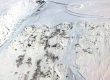
Glacial topography on 2023 LiDAR terrain model
We recently received a new LiDAR dataset commissioned by USGS, that just barely reaches far enough up Áak’w Táak Sít’ to show the problematic pocket where a lake forms and drains every summer. Because you can’t see around the corner to that little side pocket from anywhere in the valley, it’s helpful to cruise around in ArcPro’s 3D modeling tab.