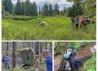
Office-day prep. Bess Crandall, in red, compares Avenza cellphone bearing (true north), to the uncorrected magnetic-only bearing on one of the cheap student compasses that we’d be practicing with on our off-trail bushwack.
Tracking & navigation workshop, upper Áak’w Táak (M-word Valley)
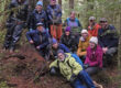
Discovery Southeast has a strong relationship with the Forest Service’s Glacier Visitor Center, dating back to former director John Neary, who facilitated our presence at the bookstore there. Visitor Center staff often join our outings, and this is especially fruitful when we convene on ‘their turf’—in this case a day-long off-trail loop through the Recreation Area, December 16th, 2024.
Most of our senior staff at Discovery Southeast are regular users of the navigational app Avenza. But we find that even avid outdoorsfolk and naturalists (hunters & backcountry skiers excepted) are typically uncomfortable off trail. This isn’t surprising, as going off-trail at all can be dangerous in tick-country throughout the lower 48. Younger nature lovers may not even remember pre-GPS days when compasses were in everyone’s pocket or daypack.
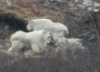
This mid-December walk had 2 themes: navigation and tracking, which are complementary in several ways. Most importantly, if you don’t get off trail, you won’t see many tracks. Wildlife concentrations of upper Áak’w Táak are mostly in the remotest corners where trails don’t currently go.
Back home, inspired by our bushwack, I decided it was time for a holidays blog post. This 29-page journal has not only my pics and maps and notes from 20241216, but from an earlier traverse of the forelands in spring, 2017, which includes drone views of the country our staff explored this December. And because many were interested in the mostly overgrown remains of a fish enhancement project in the 1960s and 70s, I’ve included background on that as well. So many of Discovery’s student adventures take place in the southern Recreation Area, that it helps to know about the Mendenhall Salmon Rearing Facility—a collaboration of USFS & ADF&G. Moose Lake, for example; do you know when and how and why it was created?
Reflecting on Discovery’s decades of bushwacking in this amazing glaciated watershed, I thought it would be apt to assemble a little slideshow about getting offtrail with friends and teachers and students:
Discovery ‘in the air’
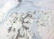
The idea for our December 2024 walk—beginning at the Visitor Center and ending at Ranger District offices on Back Loop Road—came from a bushwack I first did with Cathy Pohl in April, 2017. My journals often include ‘video-stories”—short slideshows, annotated but not narrated, capturing the day’s highlights and sometimes adding a cartographic context. I never uploaded this 4 minute tour to JuneauNature back in 2017, but reviewing it after our 2024 ‘revisit-walk,’ I’ve decided it provides a nice complement to our ground-based images and observations. Check it out, for ‘aerial context’—not only of the geography, but also our tools, like this extraordinarily detailed LiDAR bare earth. It shows not only the broadly arching recessional moraines, but even the delicate lines of mini-moraines, snapshots of perhaps a single day’s re-advance deposits from the long vanished ice-front. In most cases we don’t even notice these landforms in the field, now covered with 80-to-180-year-old forest that the LiDAR conveniently sweeps away.
BTW: handwriting on this ‘poster’ is from my mentor in post-glacial succession study, Professor Donald Lawrence, annotating a Charles Forward survey of 1936.
In the downloadable journal, above, the opening maps are presented as ‘pageflippers.’ you can fill your screen with them in Acrobat, hold a pencil to any point of interest, and toggle back and forth to compare change over time.