Goats, geology & zonation on Shaa Tlaax, moldy top (Mt Juneau)
Video-journal of the flora, fauna, and geomorphology that hikers encounter on a spring climb up Shaa Tlaax, Discovery’s backyard mountain. From giant, ‘legacy’ cottonwoods in valley bottom, to sentinel ptarmigan at 3,500 feet, rocketing cross-slope, flutter-falling back to their display posts.
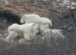
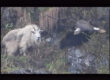
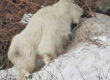
May is an amazing month in the high-country. Snow lingers in cool pockets, and a 2-hour elevational transect takes you through a month of seasonal change. The broad, ‘jungley’ band of slide alder in the giant avalanche ampitheater (now unloaded and benign) is only just leafing, and easier to search for spring warblers, foraging goats, and hoary marmots.
Since 2014, we’ve had high resolution landform mapping capability, thanks to a LiDAR dataset extending from Daxanáak, between 2 points (Berners Bay) to X’áat’ T’áak, town behind an island (Douglas town). Unfortunately, that LiDAR mission was clipped closely to the CBJ road system, extending only 500 to 1,000 feet up the slopes. Recently, I learned of an earlier, 2012 LiDAR mission, less extensive on the NW-SE axis, but in a few places ‘wrapping in’ entire watersheds, summit-to-sea. One of those is for Dzantik’i Héeni (Gold Creek) watershed. The rotating ArcScene terrain model, and geology map in this video-journal are both products of that 2012 LiDAR resource.
Downloadable GeoPDFs for navigation on this trail include one with an airphoto base, and a pair of hillshades with bedrock and surficial geology.