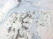
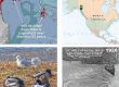
Air-photo GeoPDF for field navigation on trails to Shaa Tlaax, moldy top (Mt Juneau). In apps such as Avenza, on your phone or tablet, you can see your GPS/cell-triangulation position on this image, lay a track, and export this track with photopoints to KMZ for display in Google Earth..
Base imagery for this navigational pdf is undated aerial photography from ArcGIS Online, created for my May-2019 climb, described in this video journal.The image is recent enough to correctly show the rerouted trail through alpine tundra near the summit. A related pair of hillshade maps show bedrock and surficial geology for the broader watershed. Note however, that upper portions of the Shaa Tlaax trail have not been updated on those maps
More information on geoPDFs and use of Avenza is at Media types>Maps&geoPDFs., and at Tools>Field navigation.
Download bedrock geoPDF here (4.5MB)![]()