The earliest known encounter between European and Tlingit people was probably in 1741, when Chirikov sent a party ashore—some say at Xaayta.aan, inside the yellow-cedar village (Surge Bay) on outer Yakobi Island. They never returned, and much has been written and speculated about that event.
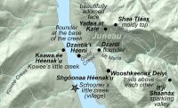
Closer to home, the first encounter was almost surely in 1794, when Joseph Whidbey led 3 small rowing craft through Áak’w Tá, little-lake bay (Auke Bay). This too was a tragic first meeting, in which one or more Tlingit warriors were apparently killed by musket fire.
The Whidbey surveys were well documented in several journals kept by the crew. The 2 most valuable records are George Vancouver’s, edited and published by W.K. Lamb in 1984, and those of Archibald Menzies, surgeon/botanist of the voyage, edited by Wally Olson in 1993. But nobody has tried to compare the various reports, enter them into GIS, and determine exactly what happened in the area now called the City and Borough of Juneau. Figuring this out requires familiarity with local topography, and an understanding of how waterways and habitats differed at the peak of the Little Ice Age. In 2010 I began to piece this story together, and I hope soon to link here to a narrated slide show detailing the events.
By the way, let’s be done with a common malapropism. Even many historians commit this error when citing what Vancouver “saw” in northern inside waters that his intrepid 1794 crew rowed through while he lay ill at anchor on the outer coast. Bad enough that George named all of our grandest landscape features for patrons and relatives back in England without suggesting that he actually saw Lynn Canal or Berners Bay. (Sorry; pet peeve.)
As Vancouver passed through the Pacific Northwest (places he actually did see), he ‘developed’ the landscape in mind’s eye—stripping off conifers and clothing hills in scenes of pastoral British productivity. He’d have been pleased to know that 135 years later, the gentlemen below (and a few wives and secretaries), would be hard at work on that dream. Heintzleman, second from left, would shepard the archipelago into the 20th Century, taming the rainforest, bumping Tleixsatanjín, hand at rest, and installing his name on the ridge dividing Áak’w from T’aakú biogeographic provinces.
Forest Service officers conference in Juneau, 1929. For background on most of these IWGs (important white guys), check out Rakestraw’s History of the United States Forest Service in Alaska (1981). It’s a 14MB download. When you’re done with that, however, best move on to a 21st-Century reality check and read Jim MacKovjak’s Tongass Timber (2010).
Documenting change through repeat photography in Southeast Alaska Carefully framed retakes of historical photographs documenting vegetation and landform change in…