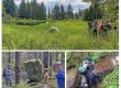
Retakes field journals, 2005 season
Summarizing the Repeat Photography Project, Kathy Hocker and I divided our reports into 2 parts: 1) aerial obliques, and 2) ground-based photos, described and downloadable here. Our plane-based retakes used GIS to replicate XYZ positions of early Navy biplanes when the originals were taken.
Download Here (6MB): ![]()

Sample spread from our Repeat Photography: Part 1 report. Antler River was fed by an active-but-shrinking glacier in 1929. When it abandoned the headwall, brush invaded the floodplain rapidly.