How did the flood behave away from our river corridor?
During the August 13th outburst flood a TFR (temporary flight restriction) was instituted over inhabited portions of Áak’w Táak, inland from little lake (Mendenhall Valley). After checking in with City and State emergency coordinators, Sean Neilson and I determined the most useful places to document flooding, from a fluvio-ecological perspective, were well away from the ‘closure-box’ running from lake outlet to just below Egan.

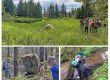
Sean with wash-down cottonwood, freshly skinned roots ripped out by the flood. Circled in distance are green-needled spruces at temporary(?) hang-up positions. Taken on mid-stage, rising tide, so we expect these were re-floated and moved farther out onto the delta. Or, like apparently the majority, swept farther out into Áak’w Tá, littlelake bay?
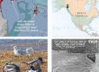
We got started a few hours after waters crested at ~7am. But the highwater extent we filmed on these broad delta and floodplain surfaces had probably not subsided much. In general we were impressed by the accuracy of predictions. Above thumbnail shows lateral extent of a 16-foot flood in pink, from the floodwatch dashboard, where the wetted road surface was an exact fit, having dropped only a foot or 2 from maximum. At peak, water was probably up around the windows of that white car, bottom center.
This is just a sampler from our 4 ‘flood-fringe’ spot-checks, starting just short of Visitor Center barracade. From westside Loop Road we also went downstream on Kax̱dig̱oowu Héen, going back clear water (Montana Cr) to where overbank spilling spread silt on the trail. Then Skaters, and finally, out to river mouth to see how many green-needle trees had hung up on the delta. Not many, compared to 2023 and 2024. How come? Tidal stage is obviously important, interacting with flow volume and duration of the pulse. But I hadn’t considered how complicated that might be.
Probably we could count how many trees flushed, from surveillance cameras recording river’s rise & fall. That’d be interesting to compare to numbers & locations of 2025 snags that do ultimately get anchored on the delta. Easy to distinguish these from the deeply embedded 2023-&-24 eagle-perch snags, who’ve lost their green needles.
Wash-down snags create habitat out there, just as LWD (large woody debris) graces our old-growth streams. Giant trees on deltas used to be a given throughout the pacific coast, when old-growth lined their rivers. The trees that sail to sea form “building blocks for stable sand dunes and spits in estuaries, buffering the rising tides and waves.” But their supply was cut off more than a century ago.
Here, in relatively intact Lingít Aaní, is where to study the dice-roll, episodic equations of their placement. Jökulhlaups are known to massively expand and rearrange deltas. But what happens to whole forests that suddenly become shipworm food, embedded in the mudflats? In cutbanks exposed at low tide, we’ve noticed dense layers of waterlogged snags, several feet below today’s surface. Could these be dated—legacies perhaps of some long-ago outburst, from some differently positioned ice-margin lake, like the Nugget Valley impoundment, near Little Ice Age maximum?
The 1988 classic on this dynamic was titled From the forest to the sea, by PNW-old-growth grandmasters Maser, Tarrant, Trappe, and Franklin. Chapter 4, by Gonor, Sedell and Benner, is What we know about large trees in estuaries, in the sea, and on coastal beaches.