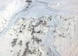
2023 aerial and surficial geology for the Blackwell tour
To kick off our 2024 summer of Blackwell walks, here’s a pair of geopdfs for navigating in Avenza. I’ve zoomed them in more closely around downtown so that more detail can be added. Surficial geology is evolved from the great RD Miller map of the 1970s, overlaid on a LiDAR-based hillshade. It has one-foot contours up to the level of maximum Little Ice Age sea level (32 feet); thence coarsening to 10-foot contours for steeper enclosing hills.

The 2023 color infrared is from imagery commissioned by the City. Thanks, Quinn! This one was shot in mid-May.