Vegetation-&-rebound study for Southeast Alaska Land Trust (SEALT)
In 2003, Discovery Southeast mapped tidal and supratidal habitats on the Refuge and adjoining lands. Focus was especially on changes brought about by rapid glacial rebound, and in some areas, sedimentation—collectively termed “accretion.” The Land Trust had recently become aware of problems with a shrinking Refuge boundary, that in places was being redefined by changing tidal elevation.

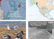
Five days of gps transects with then-Discovery naturalist Terry Schwartz, and another couple months’ processing, yielded this 2003 ‘snapshot’ of Taashuyee wetland vegetation. From historical air photos I added veg-maps for 1962 & 1979. Projecting ongoing rates of glacial rebound, I included a predicted distribution for the inconceivably remote year of 2025.

Our system maps all of these types
I still consider the map we gave SEALT to be the most detailed and ecologically meaningful for any large estuary in Lingít Aaní. Most tidal wetland mapping and “functional assessment,” while meeting criteria from regulatory agencies, disregards fundamental distinctions such as the difference between high- and low marsh (grass versus sedge dominated, respectively). Although technological advances since 2003—LiDAR, drone survey, more accurate gps & navigational apps—have made it possible to create maps like these much more efficiently, it still has not been done for any Southeast estuary I’m aware of. We can’t expect outside consultants to notice successional and trophic patterns that local naturalists have taken (literally) centuries of combined careers to document, map and understand.
As the CBJ revisits proposals for second crossings of Taashuyee, river/tide flats (Mendenhall Wetlands), it seems a good time to get this report back in circulation. Over the past 20 years I’ve learned some new tricks in presentation as well as cartography—’pageflipper’ historical series for example—that make assessment of change much easier. It’s not my intent to add new interpretive material to this old report. That should be the purview of a major remapping of this lively wetland complex.
That said, when turning 2 of the original historical series into pageflippers for easier study of change, I couldn’t resist bringing them up to date with addition of subsequent aerial imagery. Enjoy!