Stream work documentation on Tàan, sea lion (Prince of Wales Island)
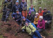
The Nature Conservancy, US Forest Service, and dozens of public-&-private partners are working to improve habitat for fish and wildlife along streams that were logged in the 1950s and 60s. In 2018, Discovery Southeast flew down to central Tàan to document these efforts.

Suk Dàa, dry around (Calder Bay, northern Tàan) had only been selectively cat-logged-&-yarded down the stream by the time of this 1956 stereopair. Drag slider to 4:40 in above video, where a 1943 B&W image shows what its photographer labeled “Calder Bay to Camp 5 logged entirely with tractors and arches” for wartime spruce production. Under a stereoscope, every tall tree stands up in exquisite 3D. In the 1970s and 90s, roads and clearcuts punched up-valley, removing the finest stands. In 2014, the watershed became Sealaska timber land.
The core of the work was a post-construction drone flight over East Middle Fork of Sdéini Héeni, man’s name river (Staney Creek) where my friend Scott Harris had flown, pre-construction, in 2016. Conor Reynolds—then with TNC—asked me to survey channel adjustments in response to logs embedded in the stream by excavator just after Scott’s flight. My brother-in-law Eric Pohl (Singularity Imaging LLC) came out from NYC to help with more technical aspects of the flying. Just in time for the trip, TNC’s Juneau office received advance drafts of high-res Phase-1 LiDAR for most of northern ¢ral Tàan, so this was a pretty heady time in terms of brand new tools, in service to old-school fieldwork.
From Conor’s initial resurvey request, this project has since branched into many aspects of the natural-&-cultural history of our southern timberlands. Most fascinating to me as a big-tree-hunter is a recently-digitized collection of high-res air photos from Tàan and neighboring forests. They were taken in the 1950s & 60s by the Forest Service and pulp mills, before roads and logging extended from beaches into island interiors. Jacob Hofman, Regional Cartographer, USFS, Juneau, organized this priceless collection. Examples from Sdéini Héeni, 1956, are given in my slideshow, above.
Ultimately I want to create a 3D historical atlas of these pre-logging forests, focusing especially on riparian reaches today deemed “functioning but at risk,”—and now seeing greatest investment, as exemplified by the Staney collaborative. Virtually ‘flying’ down Sdéini Héeni, or Suk Dàa, or Skanaxhéen, noisy-beach stream (Saginaw Creek, Kuiu Island), by sliding a stereoscope over paired 1950s images, is as close as humans will ever come to ‘sylvan time-travel.’
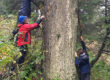
Zoomed in, over streams that—unlike Suk Dàa—hadn’t yet been cleared of LWD (large woody debris) you can count every channel-spanning 8-foot ‘ghost log,’ studying coldwater pools, broad gravelbars and lush riparian meadows that enfolded fallen monarchs. In death as in life, those spruce were ‘habitat-mothers,’ shading and hiding baby coho for several more centuries before finally dissolving, washing to sea.

Tallest spruces yet found in our 2017 LiDAR point cloud form a 1.4-mile-long belt along Sdéini’s unlogged West Middle Fork. Some stand more than 230 feet. In my opinion this is Tàan’s most important ‘control reach.’ West Middle holds my vision for what fully “restored” streams might look like to our great great great grandchildren. Screengrab from an April, 2019 drone flight by Conor Reynolds. Spanning log in foreground is about 7 feet in diameter.

In May, 2016, Scott Harris, then with Sitka Conservation Society, flew 4K ‘before‘ video on a reach of Sdéini Héeni where TNC and USFS were planning log placements. Our assignment was to replicate that flight—the after comparison. I could no more jog over logjams while looking backwards over my shoulder than do a tripleflip off the high board. Neither could my brother-in-law Eric. We said “sure! no problem!“
Many thanks to Conor, Julia and Christine at TNC, for the opportunity to work with you on this wonderful island!