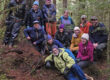
We live in kind-of a bowling alley . . .
. . . so one might hope we’ve become more attentive to the lanes and gutters. Obviously, during storms, but also, more proactively, in choice of homesites. Fortunately, we have great new tools for measurement and visualization. Here’s an example, above our downtown parking garage. If path-7 were a bowling lane, these apartments would be the center pin.
For example . . .
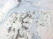
In 1936, a path-8 mudslide killed 14 people, coming to rest against the former Cold Storage building, just southeast of our present city library, on lower right of the above video-poster. That site, appropriately, is now an easily evacuated parking lot. (the ‘dodge‘, as opposed to ‘dig-in‘ strategy). You probably shouldn’t stand there admiring the Elizabeth Peratrovich mural on an autumn day when 4 inches of mudflow lubricant has fallen in the preceding 48 hours. Nor should you bushwack through that alder stand in center-poster, on the runout of even-steeper path-7.

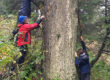
Sample from my pageflippers for proposed apartments project. Toggling through same-aligned adjacent pages in Acrobat allows point-to-point comparison for key sections of slide path-7. Forest structure on belts A-B and C-D can be viewed in the LiDAR point cloud.
At the turning of the year, I’m honoring mother nature’s paroxysms with another set of pageflippers—this time, thankfully, for an as yet untraumatized alder grove near the bottom of path-7. As naturalist and lover of Áak’w & T’aaḵú Aaní, I consider high density housing to be the most respectful way for two-leggeds to ‘make room’ for our wild neighbors, and to enhance our own quality of life. I commend the City for promoting this approach, and would happily assist in the search for safer, environmentally rational locations.