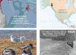
Mapping and observations in 1995

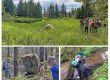
Duck Creek triangle in 1996, around the time of my study, and about a decade after relocation, in 2019.
In June, 1995, I mapped lower ‘Duck Creek triangle,’ a sliver of fenced-off remnant tidelands sandwiched between warehouses and small-plane hangars within the security area of Juneau International Airport. Managers wanted to further crowd the channel out of its 16-acre triangle into a 9.3-acre linear slot of stripped and completely visible marsh & meadow. Designs called for moving Duck Creek’s final 400 yards north to a new connection with Wooch Eelʼóox̱ʼu héen, river that’s murky together (M-word River)
Fast-forward to this winter, early 2024. For Southeast Alaska Land Trust, I’m remapping the entire Taashuyee-Chookan.aani, river/mudflat-grassy land (M-word Wetlands). Flipping through early aerial obliques over Duck’s confluence with The River (an easy closeup to shoot on takeoff or landing at JNU), I couldn’t even place them, so much has changed!
That reminded me of this mid-1990s project I hadn’t looked at in almost 30 years. It was one of the first times I considered potential for rehabilitating damaged salt marsh and alluvial corridors. Those observations, and an associated hand-drawn vegetation map, are worth reviving, as we face ongoing—even unprecedented—impacts and alterations to our treasured front-yard wetlands.