Photo strata for habitat mapping: plane, drone and foot.
Flying Taashuyee-Chookan.aani
For their 2024 February Watershed Workshop, SAWC (Southeast Alaska Watershed Coalition) asked me for some thoughts on drones as mapping tools. Timing was good because I’m assembling a gold mine of photo resources for a massive mapping effort on Taashuyee-Chookan.aai (Mendenhall Wetlands). I think of them as a 3-tier collection:
● plane-based (orthomosaics & LiDAR)
● drone-based (cloud-processed orthos & surface models, plus freeform video) and
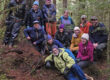
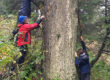
● ground-based (4,125 pics from our team of master naturalists).
Drones provide that intermediate scale, so valuable to habitat mapping. I’ve used this project to illustrate some of the opportunities and challenges we encountered, gathering Raven’s-eye views of Áak’w & T’aaḵú Aaní’s frontyard wetlands. Flights were FAA authorized through Aloft, under Remote Pilot Certificate Number 4895158. I hope these notes will be useful to others throughout Lingít Aaní who are stepping into the world of drone mapping. Send me your thoughts and experiences and discoveries, as we co-explore the archipelago from the stratum of yéil and chʼáakʼ.
The Taashuyee-Chookan.aani mapping and functional analysis was conducted by Bosworth Botanical, funded and masterfully orchestrated by Southeast Alaska Land Trust (SEALT). Partners include Alaska Dept of Fish & Game, Territorial Sportsmen, and Juneau Audubon. Our Forest Service partners at Glacier Visitor Center generously printed a large version of the draft habitat map for the SAWC-workshop’s poster session. Gunalchéesh to all for your support of these surveys!