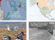
Geopdf for Middle School teachers’ adventure

Our viewshed during this cruise will be so long and narrow that I found it best when publishing to geopdf to rotate north to the left 85 degrees. Three-line placenames show Lingít over translation over colonial. Colors mostly show bedrock geology, but with a layer for post logging 2nd-growth superposed. At the confluence of Chatham and Icy Straits (oddly, the Atlas shows no Lingít name for these huge features), we will pass from Áak’w into Xutsnoowú Aaní
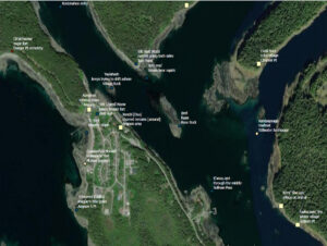
Finer scale geopdf for explorations on foot
On Friday, March 31st, 2023, we are scheduled to depart Áak’w Tá, little lake bay, for Chatlkoowú, halibut tail (Angoon ferry terminal). It’d be great if a number of teachers and facilitators had this geopdf on their phones, so that all could easily stay dialed in to our position relative to these names and features.
My TOOLS> Field navigation page explains the process of installing and using the cross-platform app Avenza. Any photo you take with your phone along our cruise while Avenza is running can be selected, along with the track, and zipped into a tidy google earth kmz, for sharing your tour and track-pinned images with friends, students and colleagues.
Once we arrive at Aangóon, isthmus town (Angoon) we can stop recording the catamaran track, shut down the coarse-scale cruise.pdf and switch over to angoon2019.pdf. This one’s based on an ArcGIS Online orthophoto, taken June 5, 2019. My knowledge of named features around Angoon is quite limited. It’ll be exciting to add to this place name collection, and perhaps correct errors in what I’ve included so far.
For those of you more nautically oriented, don’t forget the great, free, marine chart pdfs from NOAA. The chart for the first 2/3s of our cruise is 17300.pdf Southern portion is 17320.pdf. These are NOT geopdfs, so you can’t open them in Avenza. For navigation they use another format called ENC. But you can load em to your phone for trips like these, to keep track of soundings, etc on your phone’s pdf-reader. To see where we actually are, just flip back to cruise.pdf. 🙂
Hmmmm, speaking of nautical matters, and since Avenza DOES hold 3 geopdfs at once, I just happened to turn on World_Ocean_Base from ArcGIS Online’s Living Atlas library. Whoa! This raster layer goes mushy and low-res south of Yayikhéen, unseen creek of noise (Funter Bay). But until then, check out this hillshade!

Submarine topography from Living Atlas. As with previous cruise.pdf, I’ve rotated north left to 85 degrees
In our Fall, 2022 semester UAS Landforms class, we discovered that navigating with these hillshade maps helped to explain currents, upwellings, and concentrations of seabirds and marine mammals.
download bathymetry.pdf (6.5MB)![]()
Stuff to consider bringing: I find that when we’re out in the middle of a huge fiord, cellphone pictures just don’t cut it. A zoom camera comes in handy for reaching out to those faraway stream mouths, summits and cultural sites. Also, if your phone is as old and tired as mine, a recharger battery (at very least, a charging cable) will be appreciated before we arrive at Chatlkoowú. With Avenza, you can go into airplane mode, because it gets its position from your phone’s GPS, not triangulation to cell-towers.
. . .well, can’t resist one more. Back in 2012 I used multiple sources to identify clan houses downtown. Here’s a walking tour. Red-yellow spectrum dots are Raven side. Blue-green spectrum are Eagle.