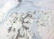
In September, 2008, I ferried to Sitka to help Sitka Conservation Society host funders and biologists. In a Beaver, we flew a huge loop, northwest up West Xunaa biogeographic province to the head of T’einaageey, hindward side bay (Tenakee Inlet), then south along Shee Ká, top of Shee (Peril Strait). Not counting one brief pitstop on Sit’kú Gathéeni Shak’áa, lake at head of sockeye creek (Sitkoh Lake), we were in the air for 3 hours—longest floatplane ride I’d ever had.

Sample spread from my journal for 20080917. Right page has flight track and linked photopoints, annotated throughout the journal. Apologies for the lack of Lingít place names! This was written before I began my naming convention, adopted around 2013.
Some include this sort of scouting under the general umbrella of “ground-truthing.” Seems to me ground-truthing should happen on the actual ground. But I love the view from 3,000 (or even 30,000) feet. It’s wonderfully educational, albeit impossible to process topographical ‘truth’ at 100 mph. And certainly this practice deserves a name—so let’s call it “air-truthing.” If you take lots of pictures or movies—in this case, 226 keepers—they’ll be worth at least a couple days scrutiny, afterward. This example from 2008 is a good illustration of my process, which continues to evolve and is described, as of 2017, here.
Even if you take only a few dozen pictures, I strongly recommend bringing along your best gps and asking your pilot to place it under the plane’s windshield. With camera and gps synched to the nearest second, you can then generate precise photopoints (red dots in this journal) along your flight track (yellow line) in programs such as Robogeo. (Smartphones can of course do this unassisted, but are way inferior to even point&shoots with a bit of zoom range.) Further tips and discussion can be found in the Methods section of my background paper for the 2017 Sewards Day retrospective, pages 12-14 in the document 1867-2017: 150 years of change.